The Pacuare River is the most famous river in Costa Rica, with thousands rafting it in the last 40 years. The majority of this is on the Lower Pacuare, which includes the popular Pacuare Gorge and where our lodge is located. New, previously unexplored sections of the river have recently been paddled, allowing for longer trips to occur. These are most commonly paddled by expert kayakers, however, occasionally rafts are taken as well. In January, we plotted the different sections on a map and have that information below, moving from upstream to downstream.
Pacuare River map
Below you’ll find a Google Map with the Upper Upper, Upper, Lower and Lower Lower Pacuare sections mapped out, with some sections containing significant waypoints.
The Pacuare River’s naming system seems strange at first, but it becomes clear with a little backstory. The initial rafted section was simply named the Pacuare. When kayakers ventured upstream, they dubbed the new section the Upper Pacuare, automatically making the original section the Lower Pacuare. As exploration continued further upstream, driven by new roads and trails, they just kept adding “Upper” to the names, resulting in the rather unusual system we have today.
Upper Upper Pacuare
The Upper Upper Pacuare is the most upstream access point as of right now. The run is 10.3 kilometers long and is mostly Class III rapids, however, there is a Class IV section towards the end of the run. The gradient is 14 meters per kilometer (75 feet per mile) which is considered steep for rafting.
Upper Pacuare
Where the Upper Upper Pacuare ends, the Upper Pacuare begins. This section has considerably harder whitewater than the Upper Upper and is characterized by many difficult rapids choked with boulders. The Upper Pacuare runs 10.7 kilometers long and has almost the same gradient as the Upper Upper at just over 14 meters per kilometer.
Lower Pacuare
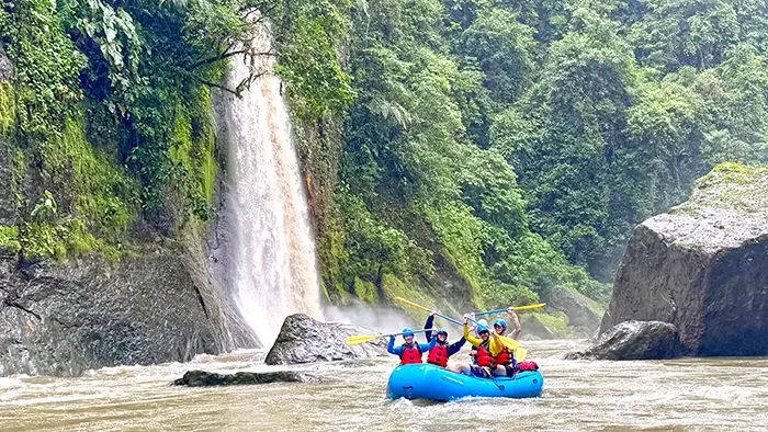
This is the section everyone knows and loves. It’s where commercial rafting is most common and will take you through tons of Class II, III and IV rapids, past famous waterfalls and a night at the lodge. This section was first run by a group of Polish kayakers in September of 1980. (The documentary of these kayakers, “Godspeed, Los Polacos!” is an amazing watch.) The Lower Pacuare is long, 26.6 kilometers, from start to finish, and falls in total 250 meters averaging out at 9.3 meters per kilometer or 50 feet per mile.
Lower Lower Pacuare
From here until the confluence with the Caribbean, the river is mild with Class II rapids and pretty quickly, flat water all the way until the end. By this point, you’re out of all canyons and you’re traversing through the lowlands past farms and small towns. This section is long, coming in at 45 kilometers from Siquirres to the Caribbean. It’s also much flatter than the rest of the Pacuare, averaging just 1 meter per kilometer.